About MAGIC-DML
Mapping, Measuring and Modeling Antarctic Geomorphology and Ice Change, in Dronning Maud Land
MAGIC-DML is an international research collaboration, with scientists in Sweden, the USA, Norway, the UK, and Germany. The focus of our work is to reconstruct the glacial history of a sector of the East Antarctic Ice Sheet (EAIS) in Dronning Maud Land. We will use the data from this ice sheet reconstruction to test and improve our ice sheet model.
In essence, we are using the nunataks as 'dip-sticks' to study how the ice sheet has thinned in response to changes in the climate.
To achieve this requires us to bring together a number of disciplines, methods, and techniques:
Mapping - Using a combination of remote sensing and field-based geomorphological mapping, we map the landforms which tell us something about past ice sheet thickness and ice sheet dynamics.
Measuring - We want to measure how much the ice has thinned and when it thinned. We use the nunataks as 'dipsticks'; mapping landforms and collecting samples at different heights between the present-day ice surface and the summit. The samples we collect are for cosmogenic nuclide surface exposure dating (CN dating). CN dating is a method that allows us to measure the amount of time the rock has been exposed at the surface – therefore providing a date at which the ice was no longer covering the sample.
Modeling - Numerical models are key to helping us understand how ice sheets work, how they may have looked in the past, and how they might behave in the future. However, in order to trust what the models tell us we need empirical (observed) data on which to test and improve the model. In the case of MAGIC-DML, the data we get from the field and lab work will be used to test and improve our ice sheet modeling and enable us to reduce the uncertainty in our modeling of future change.
Support: This project is supported by financial and logistical support from the following:
- Swedish Polar Research Secretariat
- Norwegian Polar Institute through NARE (Norwegian Antarctic Research Expeditions)
- US National Science Foundation
- Swedish Research Council
- German Research Foundation
- Stockholm University
- Helmholtz Association in Germany
- Polar Geospatial Center
- UNAVCO
- TanDEM-X
- The universities and research organizations of the participants.
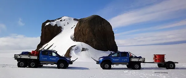
We will use the trucks pictured here to travel around the field, from one nunatak to the next. They have been specially made for us by Arctic Trucks, a company based in Iceland.
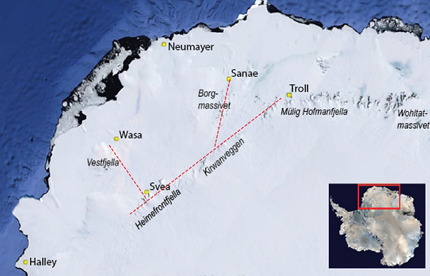
Our field area. The yellow dots are Antarctic research stations. Our fieldwork will focus on the three transects shown in red.